"Follow your inner moonlight; don't hide the madness." - Allen Ginsberg
 |
| The Appalachia Trailhead. This trailhead is famous among those who tread the trails of the Presidential Range of the White Mountains. |
The coffee was hot. More importantly it held that drug of wakefulness, caffeine. I cravenly welcomed it as the true supplicant I was. The day was getting on after the noon hour and it was getting hot. I was driving along New Hampshire Route 2 towards my next trailhead, Appalachia. It was at Appalachia that my second hike of the day would begin. I had started hiking at 11 PM the night before, and though I had taken a two or three hour nap on the summit of Garfield, I was feeling a bit drained by the 10 miles of that hike and by the lack of sleep. The next hike would also be roughly 10 miles but it would entail a more difficult hike with greater elevation gain than the last one. I knew this could be one of the toughest hiking days I would have in many years. That is not to say that hiking 20 miles in the White Mountains is a superhuman accomplishment, it surely isn't. But is is no stroll in the park either. Still, "Hope springs eternal," or "Fools rush in where angels fear to tread." Insert the most apropos cliche of your choice here.
When I arrived at the parking area for the Appalachia I saw it was full of cars and spillover parking was lining the road before and after the lot. This is not surprising as this is a very popular trailhead. So much for getting away from the crowds. Many Randolph Mountain Club trails can be accessed from this trailhead, which lies to the north of the northern Presidentials. The lot being still full at this hour, I also parked along the road and started to get my gear in order. The roadside was hot and dusty, and I was soon sweating just standing under the blazing sun. I reorganized my gear to go lighter on this hike. I did not need my sleeping bag, JetBoil Stove, extra food, etc. I just needed emergency gear, lots of water, and a little food. I could also get water along the way, either from the AMC Madison Springs Hut or from natural sources. I did take the rest of the wine with me though.
 |
| First decision point. I chose the Airline Trail. |
My pack shouldered, it was time to hike some more. I walked along the road as many bikers with numbers pinned on their backs pedaled past. Some organized road race was clearly underway this day. Turning into the parking area I walked passed cars with plates from many nearby states. I saw Massachusetts, Maine, Vermont, Rhode Island, New Hampshire of course, Quebec, New York, Maryland, New Jersey, and Connecticut. A popular trailhead indeed. A local police cruiser moved slowly through the parked cars. Unfortunately this lot has seen many vehicle break ins over the years since the evil-doers know the owners are a long way off hiking.
After stopping to quickly photograph the trailhead sign, I entered the verdant and moist woodlands at the feet of the White Mountains once again. At this low elevation, and in the heat of the midday sun, I was greeted by only one singing bird, a Red-eyed Vireo of course. Very shortly into this hike, if you are going to ascend Mt Adams or Mt. Madison, you must choose which trail you will start upwards upon. I should have read the guide book about the nature and lay of the trails prior to this choice but I had not. I simply referred to the map and chose the Airline Trail based on its course across the terrain. It would skirt the eastern rim of the dramatic King Ravine, formed by a spur of Mt. Adams and spur shared by Adams and Madison, once it broke above treeline. I very much wanted to experience the view from the edge of the ravine. But it would prove to be a more taxing climb than I was mentally prepared for in my already fatigued state. However had I made my choice and Airline Trail it was.
 |
| A fascinating fungus of the genus Ramaria. I am no expect here. I believe it is referred to as "Coral fungus." If you can add info please post a comment. |
The trail started to climb on a gentle slope but I was soon sweating heavily in the cloyingly warm humid air. My mind wandered while my legs mechanically pushed upwards. If you can still daydream while you are hiking than you are not in bad shape. It is when can't think of anything but the physical discomfort afflicting you that you are starting to get burned out. At this point I was thinking about the upper stretches of the hike, the area above treeline. The weather was excellent and the views should be spectacular. This region of the White Mountains is called the northern Presidentials. It consists of an arc of the highest summits in these crystal hills. Starting with Mount Washington as the southern anchor, these peaks fall in a crescent shaped arc with the open end being the Great Gulf, which points roughly northeast. The other peaks working along the arc away from that penultimate peak, are Clay, Jefferson, Adams, and Madison. Today's target was the terminal peak Madison, elevation just under 5,400 feet. With Jefferson, Madison was one of two peaks along this arc I had never visited.
My wandering mind was slowly recalled to the present as the trail started to increase in steepness and ruggedness. The trail bed was mainly large splintered and tumbled boulders. My already tired legs were starting to burn and I was now using my trekking poles aggressively to transfer as much effort to my arms as I could. Think of climbing a staircase for an hour or two, a staircase where each step varies in height and each tread is broken, angled every which way, and often slippery to boot. It's tough to get old. It's tougher to get old and hike 20 miles in the mountains! The first time I hiked these hills I was 23. That was some 29 years ago...
 |
| The Airline Trail gets steeper and rougher. At this point my joie de vivre was starting to have its feelings hurt. |
Onward and Upward I plodded. I passed no one and no one passed me. My energy waned as the day grew older and I sweated heavily. I started to wonder if I was up to completing this hike after having already hiked up and down Garfield. I have long known that my expectations of what I can accomplish sometimes exceeds what I should attempt. But how does one know when too much is indeed too much? I looked at the time and decided to set temporal goals. If I did not break above treeline by a certain time I would turn back. This is what I told myself anyway. Sometimes when you perceive the end to a task, the task becomes easier, finite, more "doable." So I had given myself an out, and that made me feel better. Mentally at least.
I had been grinding upwards over the shattered bones of the mountain for almost two hours when I met my first downward bound hiker. A gentleman in his sixties, or maybe even seventies, was slowly clattering down the stony trail. I say "clattering" because the that is exactly the sound trekking pole tips striking stone makes. When he drew nigh we had a brief conversation. After saying hello he asked my intended destination and route. When I told him I was planning on summitting Madison and then hiking back out again he looked a bit dubious. I wondered if I looked that badly thrashed! He passed the judgment that if I set a good pace I might make it before dark. I didn't care if it was dark when I finished or not actually. I just wanted to finish...
 |
| Mercifully the trail's angle of ascent moderated and the trail bed become more friendly. |
After passing the elder hiker I soon hit a stretch of trail that was less steep and actually had dirt instead of jumbled stone for a bed. This was most welcomed by my burning legs and wounded psyche. I was now also being passed by more and more downward bound hikers. This is a sure sign the day was getting on towards evening and hikers were heading home. The more friendly stretch of trail soon failed however and I was scrambling upwards on boulders once again. As you approach the treeline on the higher peaks you usually encounter USFS signs warning of the dangers of high, exposed elevation in the Whites. Many people have died on these mountains and not many years go by without more fatalities being added to the roll call. More often however, hikers get injured and need rescuing by dedicated Search and Rescue personnel. Fatigue often plays a role in hikers getting disabled and I was mindful of my fatigued state.
 |
| Standard USFS warning of the dangers inherent on the high slopes of the White Mountains. |
It was when the trees along the trail's route become predominantly spruce and fir that I knew I would soon climb above treeline and be rewarded for my efforts. Words simply cannot convey what it feels like to be on a mountain trail above the line where trees no longer can survive the exposure and harsh winter clime. It is a transcendent feeling, as though you have entered the world of the gods. Why the Greeks chose Mount Olympus as the home for their deities is very clear once you have walked lofty montane slopes yourself.
Finally the trees became stunted riven shadows of their lower elevation kin. This is known as "krummholz," literally "Twisted Bent Wood." As I entered this last band of forest, which was mostly shorter than I was, the panoply of the mountains lay before me. To my right was the headwall of King Ravine, and above that, Mt. Adams. To my left, rising along the mountain spur upon which I was treading, I had my first view of my goal, the summit cone of Mt. Madison.
 |
| Amongst the krummholz I get my first view of King Ravine and Mt Adams. |
 |
| And to my left, my intended target this day, the summit cone of Mt. Madison. Another mile or so of rugged trail still to go before I stand there. |
The exhilaration of the moment was mixed with worrisome concern. I still had a rugged mile or more to go to the summit and I was much more fatigued than I expected to be at this point. One should never put oneself in a position to need assistance in the mountains. That is selfish and foolish. At this point in the hike I started to lack the confidence that my legs could carry me safely back out. One slip and I could be rendered disabled and needing rescue from the mountain. With advanced leg fatigue comes greatly enhanced possibility of that slip and disabling. There are rescues needed in these mountains many time each year. I had to make damn sure I would not be one of them.
As I continued along the trail I soaked in the tremendous beauty of King Ravine and the mountains around it. I also constantly worried about my legs. I had been hiking so long and for so many miles that they felt burned up and worryingly unreliable. It was time to take a serious assessment. So I scrambled off trail to the edge of the ravine and sat. While I peered into the ravine I ate a bit and decided to drink the rest of the wine I carried. So much has been made of the restorative power of red wine that I thought, why not try it? Across the ravine, perched on the far edge, I saw Crag Camp, the Randolph Mountain Club cabin. I had visited that storied shelter last year with my young friend Mark.
 |
| The headwall of King Ravine below Mt. Adams. Believe it or not there is a trail that ascends that headwall. I have never hiked it myself but, if the gods are willing, I shall one day. |
My break lasted about 20 minutes, and after eating, drinking the wine, and contemplating my situation, I decided I would continue upwards. I was feeling better and I knew I could take as long as I wanted to complete the hike. I had my headlamp in my pack and if I needed to I could set an easy pace, with much rest time on my way out. Daylight was not a limiting factor. So I slung my pack and stood up. That was when it hit me. I was a little dehydrated and certainly very tired. My physical state combined with the wine, not very much mind you, maybe a glass and a half, had rendered me a bit drunk! I could not believe it! Well that was an unexpected twist. Between where I was and the AMC Madison Spring Hut lay a fairly level, if rugged, bit of trail. So I drank some water and hiked-under-the-influence. I took my time knowing that I had imbibed so little wine that this should soon pass.
 |
| A chunk of quartz gleams in the sunlight. The cairns of Lowes Path, which I hiked last year with a friend, are topped with these white orbs and gleam in poor light like ghostly mountain beacons. |
 |
| I reach the trail junction that points the way the hut and the summit beyond. |
 |
| Mt. Madison's summit cone above the Appalachian Mountain Club's Madison Spring Hut. |
As I approached the hut I felt the temporary drunkenness fading. Despite this I knew I needed to "sober" up totally before the summit cone. These northern presidential summit cones are simply enormous rock piles and they require sure footing and careful foot placement to traverse safely. The hut offered me a place to take another break and to eat a bit more. The summer staff, known as "croo," also offered me the opportunity to ask whether another trail would be an easier path to take out. There has been an AMC "hut" here since 1888. It was the first high mountain hut for the AMC. The current building is new, rebuilt just last year. The site it occupies is a truly dramatic one, with Mt. Adams and Mt. Madison towering above, the montane tarn called "Star Lake" nearby, and three spectacular features on the slopes below, King Ravine, Great Gulf, and Madison Gulf.
 |
| The newly rebuilt Madison Spring Hut. For nearly one and a quarter centuries an AMC hut has been standing on this lofty and glorious perch. |
Once at the hut I went inside and sat at one of the long communal tables in the dining area. The croo usually have fresh food and drink available for a small fee to passersby. I bought some fresh lemonade and ate some of my remaining trail food while watching the comings and goings. This break and sustenance finally swept the wine spun cobwebs from my normally addled brain and I was soon ready to carry on. However, before leaving I inquired of the croo whether an easier trail than Airline was to be had for the descent. Without hesitation they said "Valley Way" was much easier to use. This welcomed information did much to buoy my spirits. It was with a feeling of emotional rebirth that I exited the hut and started on my last climb of the trip.
 |
| Madison Spring Hut and Mt Adams seen from the base of Mt. Madison's summit cone. The peak in the foreground is known as JQ Adams. |
 |
| Looking upward along the cairn marked path towards the summit. |
The summit cone is a jumble of jagged boulders, some the size of cars. The official trail is marked by cairns which can be a little difficult to spot, a small pile of stones in an enormous pile of stones. I followed these cairns as best I could but mostly I concentrated on picking out my next step. It wasn't long before I was on the summit of Mt. Madison. The views were breathtaking, and they were 360 degrees. To the south stood Mt. Washington, once known as Agiocochook to the Native Americans. Between Madison and Washington lay the deep expanse of the Great Gulf Wilderness. Below the summit, along the arc of the Presidentials, lay the tarn "Star Lake" and Madison Spring Hut, and beyond that rose Mt Adams, the second highest peak in the White Mountains. To the east lay the Carter and Wildcat ranges. Northward lay the Pilot Range and Kilkenny ridge with Mt Cabot and Mt Waumbek. In every direction the eyes were rewarded with the natural splendor of northern New England. To stand on one of the summits of the Presidentials, and to fail to be deeply affected, is to be dead of spirit.
 |
| Wildcat Mountain seen from Madison's summit. The ski trails are clearly visible, as is the base of the Mt.Washington Auto Road. To the left of Wildcat is part of the Carter Range, with Carter Notch between. |
 |
| Across the Great Gulf is Agiocochook, Mt. Washington. The scar of the auto road can be seen snaking up its flank. |
 |
| Mt. Adams as seen from Madison. Below is the tarn called "Star Lake". To the right of the tarn, hidden by the boulders, is Madison Spring Hut. |
 |
| Osgood Ridge on the southeastern spur of Madison. Across Pinkham Notch lies the Carter Range with Moria, Middle Carter, South Carter, and Carter Dome. |
 |
| To the northeast of Madison is the town of Gorham in the Androscoggin River Valley. |
 |
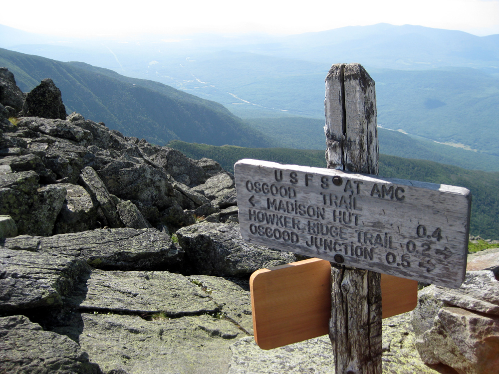
| Summit Sign. To the left, in the distance is King Ravine, and beyond, way down in the valley, is New Hampshire Route 2. I still had to hike back down to that road before my boots could come off. |
 |
| The summit area of Mt. Madison. My 42nd White Mountain 4,000 footer. 6 still to go... |
Lingering on summits is what you do. Once you have gained the peak, only lightning will drive you off quickly. I have been on summits with howling winter winds and very little visibility. I have even had my clothing freeze to boulders I leaned against on a winter summit. Still you linger. It is a very spiritual place to be, though I am not religious. So tarry I did. I spent roughly a half hour sitting among the rocks. I did speak with a few fellow hikers and took a few photographs for them, but being on these summits is a very personal experience. With a long mental sigh I finally gathered my gear and started on the final long leg of this hiking trip, the return to the Appalachia parking area and my car.
 |
| Heading back. Looking down on Madison Spring Hut and King Ravine beyond. |
As I passed the hut several people were stretched out relaxing on an open area just north of the building. Several of them asked me to join them, ladies admittedly. I jokingly asked if they had cold beer and when they said no, I responded that couldn't stop until I reached cold beer. Actually I wasn't really joking. I quickly found the trail junction that lead me to the Valley Way trail and started down. I had a long way to go and my legs were already starting to be sore with lactic acid buildup.
 |
| The beginning of Valley Way trail. |
The rest of the hike was a long slog down. My body was battered and sore. The trail was distinctly easier than Airline in that it was much more of a continuous slope instead of steep boulder strewn pitches followed by long flat pitches. Those steep boulder pitches can be deadly to tired legs and aching knees. Many an injury has happened on the descent of those steep gnarly boulder pitches. I was very thankful for the respite that was Valley Way.
 |
| The friendly road, Valley Way trail, on my way out at days end. |
Though the trail was easier on my body, it still seemed overly long in my fatigued state. As I have said before, I always set a very fast pace on the last leg out. However I had hiked so many miles at that point that my feet actually hurt. This was a new experience. My knees hurting? Not unusual. My legs hurting? Ditto. My feet? Rarely. Well they hurt now. And my arms. I had been using the trekking poles so aggressively to lessen the work of my legs that that my triceps were already sore as well. And I'm a weightlifter, so they are use to work. Just not this much work, or for so very long.
 |
| Literally the light at the end of the tunnel. The Appalachia parking area lies ahead. The day of hiking, or two days of hiking actually, are done. |
When at long, long last I saw the end of my hike, the Appalachia trailhead, I knew I was done. Done as in hiking, and done as in physically spent. When I reached my car and took my boots off I found my feet were red and swollen. I had hiked roughly 20 miles over 20 hours and had ascended two White Mountain summits, and they being far apart from one another. By the time I reached my home in Connecticut, and my head hit the pillow, I would have been awake for nearly 38 of the last 40 hours. Yes that is a bit mad I know. But a bit of madness can sometimes be a very good thing. It had been this time, under the full moon, and on the mountains called Garfield and Madison.


No comments:
Post a Comment